Siwenoid v2 map
| Language: | English |
|---|
Using Maps
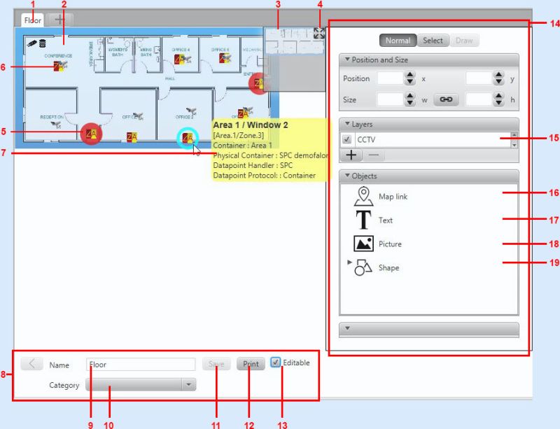
1) The parts of the screen

1) Map's name: The name of the opened map
2) The map: The saved map-image. We can zoom in and out and drag the map by the mouse cursor and wheel
3) Minimap: If we use a big map what cannot be shown at once, or we zoomed into the map the minimap shows us where we are on the bigger map.
- We can use the minimap for navigation by clicking on its window.
4) Reset button: By pressing hte button the top left corner of the map will set to the place 0x0 and the zoom of the map is set to 100%. This is the initial view of the maps.
5) Datapoint (under alarm status): Datapoints by types are represented as icons on the maps.
- If the status of the datapoint differs from "Normal" then the icon of the datapoint is highlighted by the color of the event category of the status.
- If the status is not yet acknowledged the icon is blinking.(In the example we can see an intrusion zone under alarm status.)
6) "Normal" state datapoint: Datapoints with "Normal" status are not highlighted with any color.
7) Settings options: (With the appropiate permissions) We can set the name and category of the map. Dont forget to click "save" after we make changes to the map
8) Térkép kezelő fül: A térképpel kapcsolatos lehetőségek találhatóak ebben a csoportban.
9) Térkép neve: A térkép itt elnevezhető vagy a már meglévő név átírható. A véglegesítéshez mentés gomb megnyomása szükséges!
10) Térkép csoport: A meglévő térképcsoportokból lehet a legördülő menüből választani.
11) Mentés gomb: A térképen minden változtatás ezzel véglegesíthető/menthető.
12) Nyomtatás gomb: A térkép a gomb megnyomásával nyomtatható.
13) Szerkeszthetőség: Amennyiben a szerkeszthetőség aktiválva van, úgy a térkép alakítható. pl. az adatpontok elhelyezhetőek/mozgathatóak.
14) Térkép szerkesztő: A térkép szerkesztési lehetőségei láthatóak itt.
15) Rétegek: A térképre elhelyezett elemek rétegekre oszthatóak. Ha a rétek aktiválva van a rétegen szereplő elemek látszódnak, amennyiben nem látható úgy az elemek sem láthatóak.
16) Ugró térkép: A szoftverben szereplő egy másik térképről ezzel az objektummal készíthető egy ugró térkép. Az ugró térképre kattintva azonnal megnyílik a gombhoz rendelt térkép.
17) Szöveg elhelyezés: A térképre lehetőség van szöveget írni ezzel az objektummal. Méret/szín/betűtípus is állítható.
18) Kép elhelyezése a térképen: A térképre ezzel az objektummal egy kiválasztott képet helyezhet el.
19) Alakzatok: A térképre kör/négyzet/háromszög stb alakzatokat helyezhet el.
1) Zoom: We can zoom in or out from the map with the mouse wheel. The center of the zoom will be at the mouse cursor.
2) Panning the map: You can pan the map by the mouse with click-and-drag.
If the map cannot be viewed, We can reset the map view with the button (4) if we panned / zoomed the map away from the screen.